
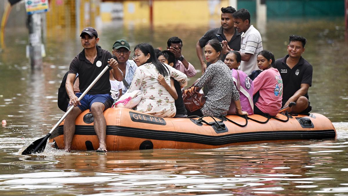
A flood of woes in Assam
Tamuli Gaon, a village in eastern Assam’s Jorhat district, is about 40 kilometres west of neighbouring Sivasagar district’s Bihubar, the epicentre of destruction by one of Assam’s worst localised floods since the 1950s. The gushing waters that submerged much of Sivasagar and adjoining Charaideo districts on July 19–20 lost momentum by the time they reached the periphery of Tamuli Gaon, but inundated the surrounding, low-lying paddy fields, to turn this village of 110 families into an island.The village’s Biju Kumar Sarmah, a teacher nicknamed Gospuli for his obsession with plantation drives to “reclaim what’s lost”, explains why Tamuli Gaon was spared. “The water did not have enough force to cut through the embankments in our area, unlike those a few kilometres to the east, toward Sivasagar district,” he says. He is not sure whether the distance from Bihubar would provide Tamuli Gaon with insurance against a bigger disaster, with at least two more months of rain to go this year. “The floodwaters have less than half the distance to travel from Bihubar to Tamuli Gaon than from Mon to Bihubar,” he says.Mon, the headquarters of Nagaland’s district of the same name, bore the brunt of extremely heavy rainfall that drenched parts of Arunachal Pradesh, Assam, and Nagaland from July 18 to 22. The rainfall triggered landslides, killing 11 people in Mon town, and large volumes of water from five major rivers and numerous streams originating in Mon district gushed downstream, carrying earth and debris, to swamp more than 80% of Sivasagar and Charaideo districts.“The water trickled in gently around noon on July 19. It suddenly became a mahapralay (total destruction), and before we could understand what was happening, we were being thrashed about in neck-deep water,” says Shivraj Sharma of Bihubar Nepalikhuti, a village near the Assam-Nagaland border that was home to some 200 families of mostly dairy farmers. Nepalikhuti is close to the Dikhow River and along the axis of the road connecting Mon to Naginimora, a border town in Nagaland that thrives on coal mining and trade. Several stretches of this road were almost erased by the overflowing Dikhow.Sharma and other members of his family clambered atop their tin-roofed house to save themselves, watching helplessly as a few villagers were swept past, flailing their arms to grab anything to anchor them. As the water level kept rising, the Sharma family — drenched from the incessant rainfall and without food for two days — feared meeting a watery grave like their cattle. “Our tethered cows could have survived if we had the time to cut the ropes,” he says. When the floodwaters receded, Bihubar Nepalikhuti was under at least 4 feet of silt with branches of trees, upturned furniture, household appliances, clothes, books, bags, footwear, utensils, mattresses, and bloated carcasses of livestock sticking out from the surface.Silt-smeared refrigerators, television sets, two-wheelers, sofa sets, packaged foods, and other items continue to flank a 19-km road from Bihubar to Simaluguri, where floodwaters caused extensive damage to an arterial railway track, snapping train services between eastern Assam and the rest of the State for almost a fortnight. The road was largely cleared a fortnight later, but most houses and structures on either side continued to be enveloped in debris. Septuagenarian Habibur Rahman recalls a “terrifying sound” as the floodwaters approached their house at Santak Bihubar village, snapping trees and slicing through anything in the way. “I don’t know when we can go back to our house. I no longer have the money and the energy to clear the head-high debris from our house,” he says.The ordeal has been similar or worse for Moromi Bora Bordoloi of Bihubar Siloni Majgaon, Ranjit Gogoi of Charing Gogoi Ali, Pithuram Konwar of Dighalijan, and Jatin Saikia of Bhitoruwal Gaon. “We were just not prepared, maybe because we are not used to such water fury,” Bordoloi, a weaver-homemaker, says.Caught unawareThe Sivasagar, Charaideo, and Jorhat district authorities, too, were caught unawares by the deluge. Chief Minister Himanta Biswa Sarma, after touring the flood-hit districts, admitted that the administration in each could not mobilise rescue and relief operations for seven days since the disaster struck. He said this was understandable, as these districts do not have a history of major floods and the authorities were not as disaster-ready as other districts that experience floods regularly.These three districts accounted for 71 of the 99 people who died in the floods across 16 districts from April to August 8, 2026, and more than 94% of some 7.21 lakh flood-affected people. The scale of the disaster across much of the 4,426 sq. km covered by the three districts is perhaps comparable to the 11-day flooding of southern Assam’s Silchar town in June 2022, with water levels rising to 12 feet in some areas. There’s a difference though: Silchar is prone to flooding or water-logging, often fleetingly, unlike Charaideo or Sivasagar.Disaster management experts explained why the government machinery was underprepared in the three districts. “There’s a flaw in the government’s approach to disaster management, which is to identify risks and concentrate on high-risk areas. The planning needs to change. If low or zero-risk areas become high-risk overnight, there’s very little people can do, as was the case with the three districts,” says Partha Jyoti Das, a climate, water, and disaster specialist with Assam-based biodiversity conservation group Aaranyak. He adds that getting the right people for climate-smart or climate-resilient flood management is crucial. “Ditto with factoring in fluctuating climate change scenarios in everything to minimise disasters.”According to the 2018 Climate Vulnerability Assessment prepared by the Indian Institute of Technology-Guwahati and IIT-Mandi in collaboration with Bengaluru’s Indian Institute of Science, Assam was the most vulnerable State in the Indian Himalayan region. The 2021 index of the same assessment ranked Assam, Andhra Pradesh, Maharashtra, Karnataka, and Bihar as the States most vulnerable to extreme climate events and hydro-meteorological disasters. The index analysed 640 districts in India and found that 463 of these were vulnerable to extreme floods, droughts, and cyclones, and that more than 80% of the country’s population resides in districts highly exposed to climate risks.Rainfall-induced floods, landslides, and erosion indicate that people in all 35 districts in Assam are highly exposed to climate risks. Often, 25-32 districts experience floods in a year, more severe in districts perched below 88 metres, the average elevation of Sivasagar and Charaideo districts. This is not unusual. A combination of geography, medium-to-heavy monsoon rainfall for almost six months, and a network of silt-laden rivers has made floods an annual phenomenon in Assam. Experts say the pattern of flooding changed after the Assam-Tibet earthquake in 1950 triggered massive landslides across the eastern Himalayas, sending large volumes of sediment into the Brahmaputra River and its tributaries and permanently altering the river system. Deforestation (Assam lost about 3,600 sq. km of tree cover from 2001–2025, accelerating soil erosion and making the rivers shallower with silt), infrastructure push in the geologically young and fragile hills, ageing breach-prone river embankments, and climate change amplified the recurring disaster, often suddenly in specific areas instead of the “laahe-laahe (slow) flooding” of yore.Hydrologists and disaster specialists are baffled by the ever-changing rainfall pattern, drenching some areas heavily and barely wetting others. For instance, while Sivasagar and Charaideo districts drowned, their western neighbours, the perennially flood-prone Morigaon and Nagaon districts, faced drought-like situations. This, perhaps, explains the monsoon paradox. According to the India Meteorological Department, Assam recorded a 28% rainfall deficit in June and July, while about 6,500 sq. km area on either side of the Assam-Nagaland border received up to 490% more rainfall than normal, contributing to the floods in Sivasagar and Charaideo.Mining menaceWhen India’s National Green Tribunal banned Meghalaya’s hazardous rat-hole coal mining in April 2014, green activists in Assam sought attention to similar, potentially “more dangerous” activities along the State’s borders with Arunachal Pradesh and Nagaland. More than a decade ago, Golaghat-based activist Apurba Ballav Goswami said the water bodies in Assam linked to the Nagaland-origin Dikhow, Disang, Jhanji, and Teyap Rivers were turning acidic due to run-off from unscientifically established mines. This, he said, was foreboding for downstream areas in Assam.A 2018 PIL (public interest litigation) filed by Congress leader Debabarata Saikia, then a Congress MLA from Nazira, in the Gauhati High Court indicated rampant coal mining was not the only source of disaster for Sivasagar and adjoining districts. It conveyed that illegal sand and stone mining and encroachment of fragile river beds were also inviting trouble. The PIL focussed on the Dikhow, Sivasagar’s lifeline-turned-sorrow, seeking an immediate ban on the potentially catastrophic riverbed mining. Following the court’s directive, the government sent teams from January to March 2019 to verify the allegations, concentrating on Bihubar and adjoining areas near the Assam-Nagaland border. The inquiry revealed eight stone quarries, 81 stone crushers, and the seizure of about 10,000 cubic metres of minor minerals in the area. The report described Bihubar and the surrounding areas as a hub of mining, distribution, supply, and interstate transportation. It also said that most of the gravel and boulders were transported from Nagaland.Saikia petitioned the High Court again in 2019, arguing that illegal mining was continuing despite the damning government report, which the court had reproduced in its order. The second petition sought a specialised mining task force, a high-powered committee to study the fragile ecosystem of the Dikhow, measures to prevent changes in the river’s course, and a master plan covering illegal mining, bank erosion, drainage, and associated problems. In October 2019, the court directed the Assam government to constitute a dedicated Mines and Minerals Task Force Battalion and a high-level committee for river conservation, adding that it expected action within three months.“The Bharatiya Janata Party (BJP)-led government virtually ignored the directive. Unchecked stone and sand mining in the Dikhow contributed to the extensive soil erosion along its course from Nagaland. The outcome is the ordeal our district went through in July,” Saikia, from oil town Nazira near Sivasagar, says. Nazira is the Assam Asset’s headquarters of ONGC, whose office-residential complex was submerged, forcing many executives to stay in hotels and homestays on higher ground.Sivasagar MLA and Raijor Dal president Akhil Gogoi was more vocal about the “indiscriminate” coal and stone mining. “Rainwater accumulated in the hollowed coal pits in Nagaland, eventually burst out and caused widespread devastation in Assam,” he says, also pointing to the “rape of the rivers” by the mining mafia. His Sivasagar-based party leader Manas Konwar went a step further, naming two local BJP legislators, one of them a Minister, as the kingpins of the stone and coal mining operations along the Assam-Nagaland border.After the floods, local YouTubers and reel-makers filmed the mining activities along the border. Some of them showed several earthen roads built across the Dikhow River to facilitate the movement of trucks carrying coal, stone chips, and sand. “Built during the dry season, these roads are like multiple dams that block the water upstream, within Nagaland. The accumulated water swells during the monsoon and cuts through these dams,” a Brahmaputra Board official says, declining to be quoted. The primary role of this Board, under the Ministry of Jal Shakti, is to plan, coordinate, and integrate implementation of measures to control floods, mitigate riverbank erosion, and harness water resources across the northeastern region.While the Assam Chief Minister, speaking to the media, denied any mining activities in Assam, community-based organisations in Nagaland rejected “theories” that their hill State and their people were responsible for Assam’s floods. Former Nagaland minister Mmhonlumo Kikon noted reports that Nagaland’s insurgent groups are financially involved in coal mining, and that mining in Nagaland materially caused or intensified the eastern Assam floods. He also said the reports frequently move from allegations, anecdotes, and general environmental risks to an implied conclusion about criminality and flood causation without producing the evidence needed to make that connection. “A clear and thorough report on the investors from Assam or elsewhere, the market where this coal is sold, the number of challans (invoices) issued by the relevant departments in Assam, or even the Assam police record on the trucks transporting the coal would have been helpful,” he says.Post-flood traumaSivasagar was formerly known as Rangpur, the administrative and political capital of the Ahoms, who ruled large swathes of Assam for 600 years until the British took control of the region in the early 1800s. Historians say Sivasagar (Charaideo was carved out of it in August 2015) was strategic for the Ahoms to administer a vast region, and that the region was relatively flood-free compared to the rest of the Brahmaputra Valley. The Ahom royal chronicles refer to flooding in and around the capital at intervals of more than a hundred years, including in 1691 and 1793.“Sivasagar’s misery indicates that the flood cycle may have reduced (after the last one recorded 60 years ago) and become more catastrophic due to several factors, mostly man-made. The unpredictable climate change scenario is adding to this misery, making old water discharge data on which flood control measures are designed redundant,” says Bibhash Sarma, an engineering teacher and consultant to Assam’s Water Resources Department. Aaranyak’s Das adds that the ever-changing rainfall pattern is the new normal. “The administrative machinery must understand that no part of Assam or anywhere else in the northeast is safe from floods and associated disasters. Everyone, down to the farmer, needs to be wired to anticipate such calamities during the six rainy months in the region.”According to disaster watchers, getting the right people for climate-smart or climate-resilient flood management will not be enough to reduce disasters in a State where living with “normal” floods has been a way of life. “Disaster preparedness has to be designed around the realisation that there is not an inch of flood-free land in Assam, and that areas considered zero- or low-risk can become high-risk overnight,” Das says. Others called for surface water management by undoing or minimising the damage done by unscientifically planned roads, flyovers, hydropower, housing, and other infrastructure projects, which have largely claimed wetlands that once acted as water sponges during floods.The pessimism “unless corrective measures are initiated now” has sunk in among Sivasagar-Charaideo’s flood survivors. Neighbours joked about taking refuge in her house during extreme floods when Lakshmi Devi began constructing her RCC house at Bihubar Nepalikhuti in 2022. In 2026, more than 60 of them did take refuge on the roof of her house when the “tsunami” struck the village on July 19. “I could not imagine then that the joke would become a reality in less than four years,” she says, mourning the loss of her 10 cows. “I may have to add another floor to our house, but there’s no guarantee that the next flood will not reach the second-floor ceiling,” she adds.District officials say the challenges in the areas returning to normality include clearing several feet of silt and debris from houses and paddy fields, sanitising the foul-smelling flood-hit areas, and ensuring adequate healthcare for livestock and people vulnerable to water- and vector-borne diseases such as Japanese encephalitis, which claimed 19 lives this year, before the floods.The biggest challenge could be the trauma of expecting the worst in a State that recorded 160 and 181 human deaths during the 2017 and 2022 floods, respectively. “I don’t think anyone in Jorhat, Sivasagar, or Charaideo can sleep peacefully, at least during the remaining two months of the monsoon this year, if not later,” says Sarmah, whose Tamuli Gaon village is 18 km south of the Brahmaputra. “The Brahmaputra has been a bigger sorrow for Assam than the Dikhow this time, and much closer to us,” he says.rahul.karmakar@thehindu.co.in
تم النشر: 2026-08-10 01:18:00
مصدر: www.thehindu.com